Proposed Post-Fire Forest Assessments
following the October 2017 Northern CA Fires
Michelle Halbur, Michael Gillogly, and OTHERS tbd
December 2017 Draft – Not for Distribution
Objectives
- Standardize rapid field methods for characterizing post-fire vegetation composition and relative degree of ecological fire impact based on published methods
- Evaluate any measurable effects of pre-fire Douglas-fir removal treatments on wildfire impacts on forest ecology at Pepperwood in field pilot
Outcomes
- Assess the impact of mechanical fuel removal pre-treatments (Douglas-fir thinning) on wildfire impacts at Pepperwood
- Assess the variability of fire impacts on forest ecology within the statewide WERT “burn severity” map categories (at Pepperwood, especially within the “‘low” category)
- Inform recommendations for regional post-fire monitoring methods to assess forest recovery in burn severity and treatment areas over time
- Inform management recommendations for fuels treatments moving forward
Douglas- fir Fuel Treatment at Pepperwood
- Treatment areas involved mechanically removing Douglas-fir trees with a diameter at breast height (DBH) of at most 10 inches (25.4 cm) using chainsaws (primarily), loppers, and other hand tools.
- Slash from mechanical removal was put into contact with the forest floor, limbed, and trunks cut to 4–6 foot-long sections.
- 2015–17 treatments included removing limbs along the trunks of larger trees that were left standing (ladder fuels removal).
- Follow-up hand removal (hand pulling, loppers) of Douglas-fir seedlings and saplings were conducted after initial mechanical removal, sometimes on multiple occasions. Documentation of these efforts both spatially and temporally is limited.
Sampling Metrics
| Attribute | When Sampled | Comments – need to elaborate in text format |
| GPS coordinates | Plot setup | UTME/UTMN for actual centerpoint location |
| Photopoints | Every visit | All taken from centerpoint, ~5m away from rebar, include rebar in photograph for consistent reference point; North-, East-, South-, West-facing; Additional photos to capture the general sense of fire severity in that plot; Azimuth documented for replication; past photopoints taken into field to ensure reoccupation and photo alignment accuracy |
| Vegetation community | Plot setup | Pulled from Sonoma Veg Map |
| Slope, aspect, topoindex, CWD | Plot setup | Pulled from GIS, slope also measured in field with clinometer |
| Qualitative description of plot | Plot setup and every visit thereafter; Post 1 (Aug-Sept 2018), 2, 5, 10 years | Noticeable land features, rare or invasive plants, general burn conditions, etc. |
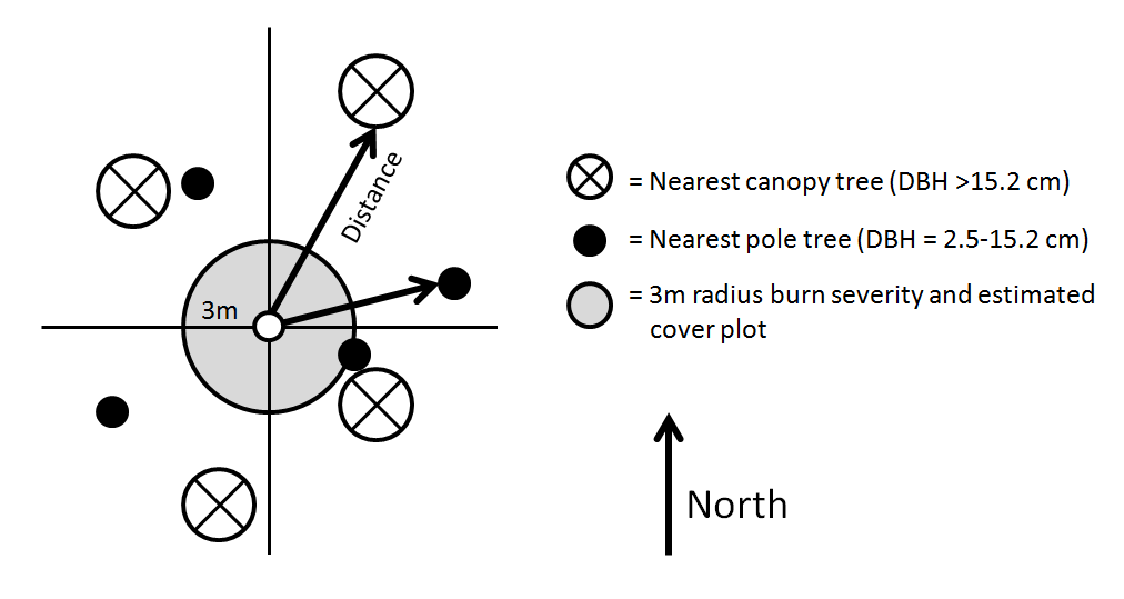
| Tree species and relative density (Point-centered quarter method) | Plot setup and every visit thereafter; Post 1 (Aug-Sept 2018), 2, 5, 10 years | 8 trees per point tagged and monitored – 2 per quadrant (NW, NE, SE, SW): nearest cover tree (DBH >25.4 cm) and nearest pole tree (DBH = 2.5-25.4 cm); may need to reassess density after a few years if new pole trees establish |
| Tree mortality | Plot setup and every visit thereafter; Post 1 (Aug-Sept 2018), 2, 5, 10 years | L=Live, D=Dead, R=Resprouting (count if present), C=Consumed/down (from fire), B=Broken below DBH (not caused by fire), S=Cut stump (after originally tagged and measured) |
| Tree health | Plot setup and every visit thereafter; Post 1 (Aug-Sept 2018), 2, 5, 10 years | Qualitative assessment of tree health – wounds, diseases, overall health |
| Tree growth and productivity; relative basal area | Post 1 (Aug-Sept 2018), 2, 5, 10 years | Diameter at breast height (DBH), live canopy cover, height to live canopy base; It is NOT recommended to measure DBH immediately after a fire – instead wait until the next Fall season or 1-year post-fire |
| Canopy cover | Post 1 (Aug-Sept 2018), 2, 5, 10 years | Canopy cover at centerpoint estimated with convex densiometer |
| Understory vegetation | Plot setup and every visit thereafter; Post 1 (Aug-Sept 2018), 2, 5, 10 years | In 3-meter radius plots based around the centerpoint: Estimate relative cover of tree seedlings (no DBH) and juveniles (DBH < 2.5 cm), shrubs, forbs, grasses, litter/duff, rock, and bare soil |
| Burn severity index (National Park Service standard) | Immediately post-fire | Recommend collecting as soon as possible up to 2 months post-fire; substrate and vegetation burn severity assessment within a 3 meter radius plot surrounding the centerpoint |
| Percent canopy leaf scorch | Immediately post-fire | Measured for 8 tagged trees per centerpoint; Recommend collecting as soon as possible up to 2 months post-fire; Deciduous trees or D-fir that dropped all needles may not be accurate or possible to estimate in January 2018; will need to figure this out in the field |
| Tree trunk char height | Immediately post-fire | Recommend collecting as soon as possible up to 2 months post-fire; Char can be due to bark or moss burn; Document highest char point even if there is a break in the char along the trunk; using clinometer angle up/down and distance from tree trunk at eye level (standing uphill from tree) |
| Cambium burn height and circumference | Immediately post-fire | Document severe, visibly apparent, burning of the cambium layer that may compromise tree canopy and affect mortality; Burn height is measured from the base of the tree to the uppermost point; Burn circumference is measured at the widest point; Does not include severe bark burn where the heat may have killed off the cambium (we are not etching into the tree to check for cambium color); If multiple cambium burn sections, document greatest height and add up all widest circumferences for one total circumference |
Sampling Point Stratification
Sampling points were stratified across the variables listed below. Specific locations were selected randomly and remotely using GIS. Points were preferably placed near treatment edges, paired (treated and untreated) in the same vicinity, and at least 100 m apart and at least 50 m away from the treatment edge if possible. WE MIGHT CONSIDER TRANSECTS IN TREATED/UNTREATED VEG COMMUNITIES TO INCREASE REPLICATION
- Time since Douglas-fir removal (2006–2017)
- Vegetation community (Sonoma Veg Map Alliances)
- Black oak (Quercus kellogii)
- Coast live oak (Quercus agrifolia)
- Oregon oak (Quercus garryana)
- Douglas-fir (Pseudotsuga menziesii)
- Soil burn severity map
- Very Low (1 pair of plots)
- Low
- Moderate (1–2 pairs of plots)
- Treatment type
- Untreated (U) – This category may include areas with or without Douglas-fir encroachment before the fire came through. There is no slash from management activities on the forest floor.
- Treated (T) – This category has been treated mechanically for Douglas-fir and has slash on the forest floor.
Sampling Point Setup
Sampling design is based on the plotless point-centered quarter method (Cottam and Curtis 1956). We will establish rebar with a protective tennis ball at the centerpoint and the sampled area will be based on the distances to the nearest canopy and pole trees in each quadrant. See the figure below for details.
NPS Burn Severity Coding Matrix – Specific to Forest Communities (Page 110 from USDI National Park Service. 2003. Fire Monitoring Handbook. Boise (ID): Fire Management Program Center, National Interagency Fire Center. 274p.)
| Index | Substrate (S) | Vegetation (V) |
| Unburned (5) | not burned | not burned |
| Scorched (4) | litter partially blackened; duff nearly unchanged; wood/leaf structures unchanged | foliage scorched and attached to supporting twigs |
| Lightly burned (3) | litter charred to partially consumed; upper duff layer may be charred but the duff layer is not altered over the entire depth; surface appears black; woody debris is partially burned; logs are scorched or blackened but not charred; rotten wood is scorched to partially burned | foliage and smaller twigs partially to completely consumed; branches mostly intact |
| Moderately burned (2) | litter mostly to entirely consumed, leaving coarse, light colored ash; duff deeply charred, but underlying mineral soil is not visibly altered; woody debris is mostly consumed; logs are deeply charred, burned-out stump holes are common | foliage, twigs, and small stems consumed; some branches still present |
| Heavily burned (1) | litter and duff completely consumed, leaving fine white ash; mineral soil visibly altered, often reddish; sound logs are deeply charred, and rotten logs are completely consumed; This code generally applies to less than 10% of natural or slash burned areas. | all plant parts consumed, leaving some or not major stems or trunks; any left are deeply charred |
Field Supplies List
- Rebar
- Protective tennis balls with slits cut
- Tree tags – pre-numbered
- Tag steel die kit
- For additional limbs/branches (###.1 for first branch below DBH, ###.2 for second, etc.)
- Writeable metal tree tag – for centerpoint IDs
- Hammer
- Nails
- 14-gauge wire – hanging tree tags for smaller trees
- Wire cutters
- Camera charged with extra battery
- GPS unit with extra batteries
- 100 m transect tape
- DBH tape
- Flags – for 4 cardinal directions, for 3m radius cover plot
- Clinometer
- Pencils
- Maps
- Data sheets
NOTES – Point-Centered Quarter Method – Cottam and Curtis 1956
Plotless distance method that calculates: 1) relative density, 2) relative frequency, 3) relative basal area
REFERENCES REVIEWED
Cottam G. and Curtis J.T. 1956. The use of distance measures in phytosciological sampling. Ecology 37: 451–460.
Fites et al. 2007. Fire behavior and effect relating to suppression, fuel treatments, and protected areas on the Antelope Complex: Wheeler Fire.
Fites-Kaufman et al. 2013. Evaluation of Wildland Fire Use Fires on the Sequoia and Stanislaus National Forests in 2003: Effects in relation to historic regimes and resource benefits. USFS, Adaptive Management Services Enterprise Team.
Mitchell, K. 2015. Quantitative Analysis by the Point-Centered Quarter Method. Department of Mathematics and Computer Science Hobart and William Smith Colleges Geneva, NY
USDI National Park Service. 2003. Fire Monitoring Handbook. Boise (ID): Fire Management Program Center, National Interagency Fire Center. 274p.
[embeddoc url=”https://mikefitz.us/capstone/wp-content/uploads/2018/05/17-12-28-paired-sampling-example-PWD_MGT_Post-Fire-Forest-Asessments.pdf” download=”all”]
[embeddoc url=”https://mikefitz.us/capstone/wp-content/uploads/2018/05/17-12-28-Post-Fire-Forest-Assessment-Data-Sheets-DRAFT.xlsx” download=”all” viewer=”microsoft”]